Parque Nacional Yaxha, Nakum and Naranjo (PNYNN) has five lakes or lagoons in a row, east to west. One of these lagoons is missing from 50% of international maps and most websites (on lakes, lagoons, lagos, lagunas of Guatemala).
A second lagoon, a kilometer northwest, is missing from 99% of Guatemalan and international maps and 99% of websites (FLAAR put this three circular connected ponds back on the map during our 2018-2019 project with IDAEH+CONAP co-administrators of PNYNN). These past field trips will be reported on in separate upcoming reports.
- The present webpage is to help ecologists, geographers, archaeologists, botanists, and zoologists learn where lots of remarkable scientific biological discoveries can be made in the future.
- The present webpage is to rescue lost and forgotten lagoons of RBM.
- This post is also to link to a separate report-in-preparation that one lagoon may be remains of three conjoined cenotes
A second lagoon, a kilometer northwest, is missing from 99% of Guatemalan and international maps and 99% of websites (FLAAR put this three circular connected ponds back on the map during our 2018-2019 project with IDAEH+CONAP co-administrators of PNYNN). These past field trips will be reported on in separate upcoming reports.
 |
|
The smallest lagoon is more visible on the website Satellites.pro. |
|
|
 |
|
CONRED uses helpful blue colors for lakes and lagoons, but lacks name for the smallest of the lakes. Laguneta Perdida (Laguneta of 3 Conjoined Cenotes) is north of Laguneta Lancaja but is not pictured on the CONRED map but of course is clearly visible on any satellite view. The park rangers told us they were so surprised and so elated to see these “never before documented” wetlands that they were breaking out in tears. I have cried twice when hiking (sliding down the steep karst fault line area to see the sizeable Savanna East of Nakum). |
|
|
Laguneta Perdida is not presented as a named lagoon in 99% of maps of Peten; we are working to document the uniqueness and importance of this lagoon. We discuss this in our separate work-in-progress on cenotes in Parque Nacional Yaxha, Nakum and Naranjo. I have named this Laguneta of 3 Conjoined Cenotes because its shape looks precisely like three cenotes, but conjoined. Geologists can prove or disprove whether it is the remains of three conjoined cenotes, but this name will hopefully attract scientific field work by geologists.
Even Google Maps does not have correct names for all these lagoons
Google Maps does not give you the names of the lakes and in one of their maps the small lagoon west of Yaxha is not even shown (because in the satellite view its water did not reflect white from clouds?). And the lake at the far west is called Laguna El Ramonal and is named an ecological park. The official government name is Laguneta Champoxte but the local name for the same lagoon is Laguna Ramonal because of all the ramon trees around the area. I am not aware of any ecological park in the Laguna El Ramonal area since officially it’s supposed to be part of PNYNN.
CONRED has the best maps of anyone: they name the far west as Laguneta Champoxte, the middle one as Laguneta Lancaja, no name for the tiny one but at least it is shown. The Laguneta of 3 Conjoined Cenote Shapes is pictured but not named.
Laguneta Perdida is in the Municipio de La Libertad. It is common for lakes and rivers to have same name in many areas.
My text for a recent ZOOM by FLAAR Mesoamerica presentation lists:
De este a oeste:
- Laguna Sacnab
- Laguna Yaxha (este es nuestro enfoque principal, especialmente el lado sur, el extremo suroeste y la esquina noroeste (área con “forma de cenote”).
- Laguna Julequito (también deletreada Juleque y también llamada La Guitarra)
- Laguna Lankaja (Lancajá). Unclear whether it should be spelled Lacanja.
- Laguna Perdida (3 piscinas grandes en forma de cenote unidas en sus bordes)
- La Laguna Champoxté está ocupada por el lado sur; entonces nuestro foco son las otras lagunas).
At that time I did not yet know that Laguna Champoxté was better known as Laguna Ramonal. And now I realice that laguna is not the correct word for small water areas; they are Laguneta. Sacnab and Yaxha are both Laguna. But the others are all Laguneta:
- Laguneta Julequito (totally absent from Google maps; shown as water but not named in CONRED map). Also known locally as La Guitarra.
- Laguneta Lancaja
- Laguneta Champoxté
- Laguneta of 3 Conjoined Cenotes is not named by CONRED.
The smaller Lagoons that are ignored, forgotten, often not even on maps
Almost none of the names of the small lagoons show up in Google: La Laguna de la Guitarra is what you get (nowhere near Peten!).
When you Google Julequito you get “El Julequito, Caserío El Quetzal” on Facebook.
Laguneta Lankaja (Lancajá). Unclear whether it should be spelled Lacanja. But actually Lacanja is incorrect. Fortunately www.deguate.com has at least two of the small lagoons correctly named.
La Laguneta Lancajá, también corresponde a la clasificación de Laguna y su localización se encuentra específicamente en el caserío La Bendición, municipio de Flores, Departamento de Petén, Guatemala.
Esta hermosa laguneta colinda al Este con la laguneta Champoxté y al Oeste de la laguna Yaxjá. Se encuentra a una Latitud Norte de 17°04’09.4” y una Longitud Oeste de 89°27’48.8”. Cuya elevación es de 180 metros sobre el nivel del mar.
El cuerpo de esta laguna posee una superficie de 0.7 kilómetros cuadrados. www.deguate.com/geografia/lagos/laguneta-lancaja-peten.shtml
Laguneta Juleque, Petén
Pequeña masa de agua que se encuentra localizada al Oeste de la Laguna Yaxjá y al Norte de la Laguneta Lacanjá, específicamente en el caserío El Quetzal, municipio Dolores, Departamento de Petén, Guatemala.
El embalse natural tiene una superficie de agua de 0.12 kilómetros cuadrados. Se encuentra a una Latitud Norte de 16°38’39” y una Longitud Oeste de 89°37’10”, a una elevación de 301 msnm.
www.deguate.com/geografia/lagos/laguneta-juleque-peten.shtml
I do not understand how this lagoon can be in the Municipio de Dolores and the adjacent lake a few meters away is in the Municipio de Flores. Is Lake Yaxha also in the Municipio de Dolores?
 |
|
On the website SatellitesPro you can see the lakes clearly. At the right is the far west end of Lake Yaxha. You have to climb up a very steep hill and then slide down the other side to see Laguneta La Guitarra (Juleque). Laguneta Lancaja is at the left; Ramonal is further west (we show that in other photos). |
|
|
Laguneta El Juleque is another way to write the name; under this name it appears (barely; the Laguneta of 3 Conjoined Cenote Shapes is not pictured nor named)
https://mapcarta.com/es/35094280
We also need to check the level above the sea; it is unlikely that Juleque is 70 meters above Lancaja. And we really need the altitude of the plateau on which is the Savanna of 3 Fern Species and the nearby Laguneta of 3 Conjoined Cenote Shapes.
| Laguneta of 3 Conjoined Cenotes | Laguneta Champoxté o Ramonal | Laguneta Lankaja o Lancajá | Laguneta El Juleque o Laguneta la Guitarra | Laguna Yaxha | Laguna Sacnab |
| Unknown, needs to be measured | 190 meters | 180 meters | 301m (not acceptable without documentation) | 190 meters | 180 meters |
| No info | www.deguate.com | www.deguate.com | www.deguate.com | www.deguate.com | www.deguate.com |
Laguna Perdida or Laguneta Perdida should be renamed Laguneta of 3 Conjoined Cenotes
Laguneta Perdida is a hopeless name since there is a larger Laguna Perdida elsewhere in Peten (west of Lake Peten Itza). So when you Google this name (Laguneta Perdida) you get the other lake 99% of the time. You only get the triple-cenote-shaped lagoon when one of my web pages turns up (copied, pasted, and used without any permission whatsoever by dozens of other sites). So I seriously suggest the unique name Laguna de Tres Cenotes Unidos.
 |
|
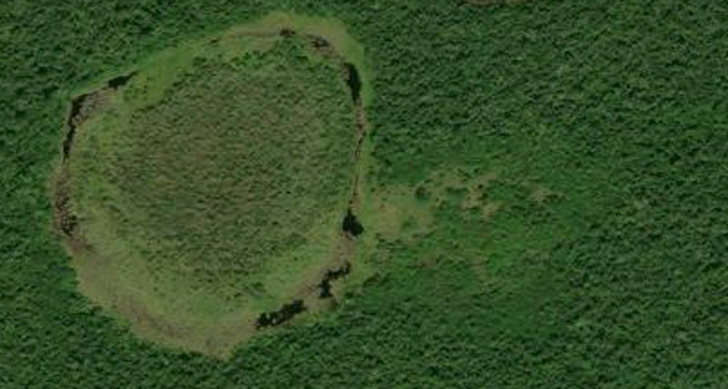
This is what I saw on Satellites.Pro website in 2018. We told park rangers about this and they went to find a trail. Once they knew how to get there easily, we planned a joint trip (went twice). To my knowledge this lagoon and the bog/savanna below is not listed, documented, or known to previous biologists, geographers, geologists, botanists, or zoologists (curious if crocodiles are here, since this is quite high above the level of the east-west series of lagoons below). |
|
|
The wetland below (the oval one) is a bog, seasonally inundated wetland that I have named “Savanna of 3 Fern Species.” There is a rectangular savanna adjacent to the east that we have not yet explored to its eastern end.
 |
|
Savanna of 3 Fern Species is the oval area with a ring of water around it. The rectangular area to the right is more traditional savanna (but no pine trees). |
|
|
Cenotes in Yaxha and Lake Yaxha areas of PNYNN
We are working on a webpage and a FLAAR report to show the location of all the other probably cenotes around Lake Yaxha. There is one also probable collapsed cenote inland about 80 meters, that I noticed when living and mapping Yaxha starting about 1970. We will link to those pages and .PDFs as soon as they are ready.
Lots more lakes in a row east to west from PNYNN past Lake Peten Itza
- Laguneta Macanche
- Laguneta El Tintal
- Laguneta Botanal
All three of these above are close to each other. Then you get:
Laguneta Salpeten, with (salada) in parentheses, maybe because the water is very different composition than the lakes on either side. Then you get:
- Lake Peten Itza
- Laguneta Picu
- Laguneta Yalgobach
- Laguneta Yalmojan Laguna Sacpuy (I dislike naming a water space of this size as a Laguneta)
Starting list of reports and websites that at least mention “the missing lagoons” of PNYNN
I thank Gabriella Moretti for telling me the common names of the string of lagoons west of Lake Yaxha.
We are searching for more references but here are some to start with.
- 2011
- Ecosistemas de Guatemala. Zoom presentation 24 de abril 2021. Ecosistemas de Guatemala-PPT-Nicholas-Hellmuth-24-abril-2021-Curso2-JG-edit-VG (6).pptx
www.deguate.com/geografia/lagos/laguneta-juleque-peten.shtml
www.deguate.com/geografia/lagos/laguneta-lancaja-peten.shtml
We can’t find any report by dequate.com on the “overlooked, forgotten, unknown” Laguna de Tres Cenotes Unidos
https://mapcarta.com/es/35094280
Shows a pin for Laguneta El Juleque but shows no blue water symbol, nor for the lagoon to the immediate left (only for the larger one further west).
http://biblioteca.usac.edu.gt/tesis/02/02_1748.pdf
Each different page or map spells the names of the lakes differently (p 53 map compared with page 54 map).
First posted July 2021