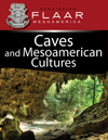
Yaxlik Cave, Chi'kelex, (Yazlik, Chiquelex), Alta Verapaz
There tend to be various ways to spell local words, but evidently Yaxlik is the closest to the correct way.

The cave is of moderate size. All of us enjoyed the experience of the geological formations inside the cave. I did not notice any archaeological remains but our purpose was not archaeological (since there are plenty of specialists in cave archaeology). For us the goal was to get plenty of healthy exercise by hiking back and forth, and to enjoy the natural beauty of the caves.
Caves are symbols of the Underworld to the Mayan people and whereas most tourists go to Chichicastenango to see the local (K'iche') Mayan people, I am trying to learn K'ekchi' (Q'eqchi') Mayan language so I tend to spend weekends in the Alta Verapaz area of Guatemala.

I have been exploring caves since I was a child in the Karst area of Missouri. Since we have so many caves on our family farm in the Ozark Mountains, two of my brothers are also cavers: architect Daniel Hellmuth has also come to Guatemala to experience the caves of Candelaria about five years ago.
I was in Shanghai for a week before this cave trip. FLAAR is consultant for wide-format inkjet printing technology around the world, and the organizers of the largest printer trade show in the world flew six of us to China to assist them. So on the hikes this weekend I had a tad of jet lag from all the flights: Shanghai-Beijing-LAX-St Louis. I then went to Chicago to have a meeting about the actual Popol Vuh in the Newberry Library; and then flew to Guatemala and drove to Senahu to pick up our translators and then we drove to the cave.
I can't count the miles or kilometers to get to this cave, nor the thousands of footsteps balanced precariously above needle-shaped rocks along the river or in deep mud through the milpa maize fields on the long hike to the cave. But the hike is good exercise. And not slipping means your brain has to calculate the height, distance, of every rock along the river's edge, and whether that rock will break or slip when your weight is upon it.

Here is the group who were on this cave visit: this was like a family weekend field trip (as you can tell by the kids), with FLAAR staff and K'ekcih' Mayan interns and students who are being trained in graphic design and illustration. Plus the local guides.
How to access the Yaxlik cave
There are two ways to enter and leave the cave in sense of getting from the camp, which is as far as your vehicle can be driven: we went to the cave along the riverbank. The Chiacte River was really high during the monsoon rainy season, so no way to cross and no way to use other safer trails (meaning trail with less sharp rocks).

The river trail was slipperly and literally dangerous from potential of falling and scraping what is left of you shins and buttocks (not to mention your elbows).

We were told the hike would be 30 minutes. This is local slang for a hike of about 45 minutes. But at least there was not too much steep climbing up or steep climbing down. But most of the hike once you reach the river was balancing yourself from rock to rock; most of the way there was no flat trail whatsoever.
Leaving the cave it was night. We all had flashlights so the lack of sun was not an issue (and there was a moon). But in the darkness, even with flashlights, the hike along the edge of the river would have been too dangerous. So we took the alternative route; about hour+ and several loooonnng steep hills. At age 69 I must admit these long steep climbs took their toll on what was left of my strength.
I had gotten to the caves (even running through the flat maize fields since the area was so beautiful) due to having consumed a Coca Cola before leaving the truck (and about 20 Hershey's chunks of dark chocolate with nuts). But after the initial hike to the cave, and then hiking through the cave and back out, the CocaCola+Hershey's supercharged energy boost had been expended. All I had left were two things:
- the fact that unless I could climb the mountain and hike through the hills I would never leave this valley.
- And second, I used adrenalin (since I had no strength left I called up my adrenalin).
Every time I slipped I grabbed for a branch to steady myself. This is a great way to do a botanical study of different plant species with different sizes and shapes of thorns and spines.
On the way out of the cave I slipped against a tree branch with tiny but sharp spines. Got about four spines stuck into my scalp (last time this happened was in my ethnobotanical garden when I slipped against a palo de pito tree. That thorn went so far into my scalp that I had to go to emergency room and have the thorn excavated by a surgeon). Fortunately this was in the city and the main private hospital is 12 minutes away and offers great service at about 20% of the price of a hospital in USA or Europe.
One of the staff spent many hours with a pin excavating spines out of his thumbs and finger tips. I still have the stub of a spine in my thumb as I write this.
How to get to the finca on which the cave is located
There are no signs at most intersections since most people do not have cars so there is hardly any traffic. So you need to ask local people at each intersection. It helps to have a Q'eqchi' Mayan translator in the vehicle with you (we had four people from Senahu in the pickup).
First, have a Google map, since no highway map will show any of the roads in this remote area. Do not count on having access to Internet signal either (in other words, print out the satellite map before you leave your hotel).
No map, and not even Google, will provide the names of local Q'eqchi' settlements (aldeas). So it helps to have a local person in the vehicle with you if possible.

We do not recommend driving at night on backroads. Look at the washed out road here, repaired with logs. But…. there was a further washout on the other side of the logs; not even 4WD would have survived if your tire slipped off the logs. And have one person outside the vehicle to guide the driver.

We tried one road, and it was totally washed out. In the photo you can see that even with 4WD we could not have handled what was left of the road. So this wasted about an hour since we had to turn around the find another road.
The drop on the far side of the logs was perhaps the height of a 30 story office building! The drop down into the hole on the other side of the logs was also an endless distance. Welcome to caving in remote areas.
It helps to have 4WD in areas such as this, but it must be high-axel construction. We took a Volvo 4WD SUV on another route and its underside was shredded by the rocks on the roads (the roads are occasionally not flat whatsoever).
|
FLAAR Mesoamerica has no vehicle of its own, so we appreciate Ricky Pilling providing his 4WD Toyota double-cab pickup for this excursion. The only vehicle large enough to hold the entire team, plus the equipment, would be a Chevy Suburban or GMC equivalent (4WD models). With the pickup several members of the team had to be in the open back of the truck. If you put a cover on, then there is no space for people in the back.

Nicholas Hellmuth and his guide, on their way to the Yaxlik Cave, July 2014. Notice the steep narrow trail (with a direct falloff into the raging river to the left).
Posted July 2014