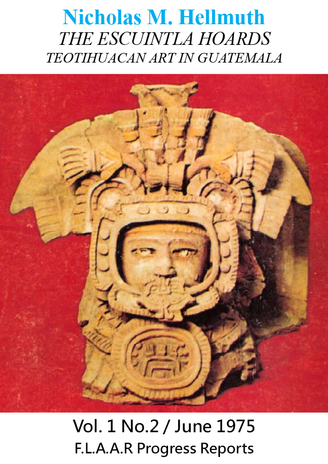
Pine, oak, and tasiste palm 3km east of Tikal National Park
The area of pine east of Tikal is well known because there are NO pine trees INSIDE the Tikal park; and NO pine trees inside the adjacent Parque Nacional Yaxha, Nakum and Naranjo. Yet there are millions of pines in many areas of southern and western Peten and even more millions of pines across areas of Belize to the east. But in the Maya Lowlands, most of the pine trees of Peten are around La Libertad (west of Flores/Santa Elena/San Benito, towards Sayaxche). Even more pine are around Poptun in south-central Peten. And of course the pine oak forests of El Progreso and more in Baja Verapaz and elsewhere in the Maya Highlands.
In other words, not much pine yet found in the Reserva de la Biosfera Maya. We have not found on single pine in PNYNN and no field work has found pine inside PANAT; only the island of pine a few kilometers east of the northeast corner of PANAT. This pine oak tasiste forest is in the Bajo de Santa Fe. So these pines and oaks are not growing on the side of limestone hills. Whether ground level the pine area is a few centimeters higher than the surrounding bajo another project would need to determine this. Lundell calls the pine area a hammock.
 |
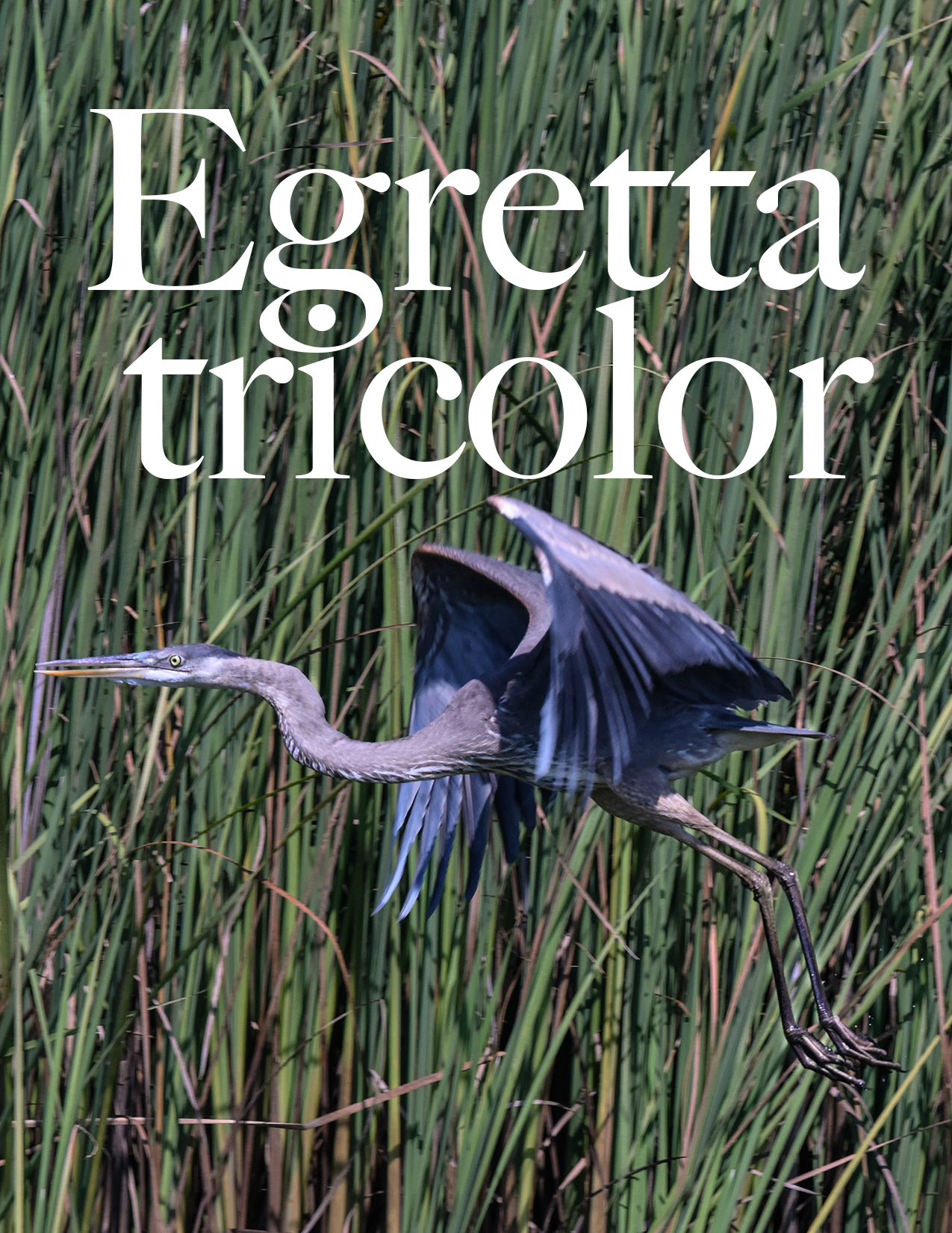
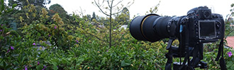
This pine area is known to all archaeologists, ecologists, biologists, geographers who work in Peten. But I have not yet found photographs, and definitely no aerial photos that show what’s here. So FLAAR brought its licensed registered Mavic 3 drone piloted by experienced aerial photographer Haniel Lopez. This aerial photo is deliberately diagonal so you can see the pine and the tasiste palm plus the dozens of other tree species which include oak, nance, etc. So far we ourselves have not seen Crescentia cujete here. On most hills, pine and oak are the primary trees; most other trees do not like to grow where pines scatter their needles on the ground. But here in this bajo area, there are tree after tree after tree surrounding the pines. This area needs several PhD dissertations and needs an aerial map (with a Phase One iXM UAV aerial camera on a DJI M600 drone with special lenses made for the Phase One camera. This 100 MEGApixel aerial camera can use multi-spectral software and other mapping software. If funding were available as a donation to FLAAR (in USA) or to FLAAR Mesoamerica (in Guatemala) we could take this aerial camera and map unique biodiverse ecosystems throughout the Reserva de la Biosfera Maya. |
Was ethnobotanist Cyrus Lundell the individual that first reported this pine area?
Of ecological significance is the discovery of a pineland hammock in the Bajo de Santa Fe. Its vegetation is essentially the same as that of similar plant associations in Belize. My exploration of this hammock added a number of species to the flora of northern Peten (Wrightia 2: 111-126. 1961). Pines were important as torch wood.
(Lundell 1984: 72)
The pinal, an isolated hammock of some two square kilometers, is located about 10 miles 77° ENE of Tikal.
(Laws 1961: 127)
We discuss the discovery of this pine area and the initial visit by botanists in our FLAAR Reports to show our aerial photos of the pine area and panorama and close-ups of the tasiste palm areas.
How to get yourself to the pine area to experience this in-person?
Drive from Uaxactun a few kilometers then turn left. This is a lumber road of the Uaxactun lumber concession. This road has so many side roads and turnoffs that be sure your guide is from Uaxactun and knows precisely how to get to the pinar area. Finally there is a turn off to a less-used road (half the width of the others). You need a chain saw to get through because wind storms blow down trees every month. If no chain saw at lease two individuals with sharpened machetes. Plus then you have to pull the trunks and limbs off the road.
If a large tree has fallen across the road, a machete is not realistic; hence the need for a chair saw. Since we had no chair saw, we reached a point where we could not drive further, so we parked the 4x4 and started to hike. After about a kilometer we passed through a corozera with lots of guano palm also. This deserves to be studied with aerial photos and panorama photos. Since we had to hike so many hours back and forth to reach the pine area, we did not photograph this corozal area.
Eventually you reach the end of the “road” and hike on a trail. Much of this trail goes down a low gully (totally dry most of the year). This trail is easy to hike.
Then eventually this trail reaches the brecha that does around the north, south, east, west part of PANAT. You climb a hill and then keep going straight (on the several-meter wide brecha). We saw a puma hiking on the same brecha, but so far away that even with 600mm telephoto lens it was hard to get a snapshot. This brecha is wide and where you walk is clean (so you don’t trip over stumps hidden by fallen palm fronds or other leaves).
Eventually you get to the northeast corner of PANAT and you turn south and hike not a long distance. Then find a narrow path eastward towards the pinar. This trail is brutal since the grass and fallen palm fronds cover the spikes of the saplings and palms cut for this narrow trail. Plus you can’t see the raised roots of nearby trees. So your toes hit the roots or cut trunks and you trip and fall and as your hands try to stop your body from hitting the ground your open palm hits a spike-shaped top of a cut sapling. These many kilometers were the most difficult of the entire hike. But you continue because your mind wants to see the pine in-persona (so more than in an article or on a web page). I was so exhausted and found this trail so difficult that my mind had to promise my worn out legs that it was crucial to see the pine in-persona.
This entire area is a bajo forest but the ecosystem changes. I did not notice any palo de Campeche (lots on the brecha around Tikal park but not as much after you go east). There may have been some the first kilometer but I doubt after the series of “rivers.” These rivers are where, at the height of the rainy season, water flows fast enough to leave obvious signs when you hike this area in the dry season that it’s a river in the wet season. All is covered by shrubs and lianas; we will check to see whether this is noticeable from satellite view. In the dry season there is not a drop of water here.
Then gradually you notice that the palm trees are no longer guano; the palm trees are now tasiste, Acoelorrhaphe wrightii. And soon you see you are in a tasistal area: thousands of tasiste palms but still lots of other scrubby trees. The difference is that a normal tasistal is burned by intrusive local hunters were year or at least every three years. So these fires eliminate most of the other species that are not fire-resistant. I estimate that this area was a tasistal in the past and that the other trees of the surrounding bajo invaded this space because of no fires being set. But the tasiste palms still survive even without occasional fires.
As you hike there are some areas with no tasiste whatsoever; then areas with just a few; then areas with hundreds of tasiste palm on both sides.
No Crescentia cujete was noticed. This was unexpected because usually calabash trees are in tasistal areas and in 90% of the savannas that we have hiked through in the RBM area of Peten (especially PNYNN and PNLT). So far I have not found Crescentia in the 1961 list of Lundell for the pine area.
Nance trees we estimate are present but with no flowers or fruits they are not as easy to see. Lundell lists two different species. Both are still accepted names today: Byrsonima bucidaefolia Standl.
Byrsonima crassifolia (L.) H.B.K.
Oak trees would be expected among the pine area but we were literally “walking dead” by the time we got here. Byron had blisters on his feet because his hiking boots were new. At age 78, a hike on the improvised trail the last several kilometers was tough for me (plus we all then had to hike 10 kilometers back to the 4x4 to drive many more kilometers back to Uaxactun). Lundell and others list oak trees in this area; this area should be called Pine-Oak-Tasistal instead of just pine area.
When we saw the first pine trees I noticed how “thin” the branches were and how high they grew above the surrounding bajo vegetation. I would have expected a hill, like the pine oak forests above the bosque seco as you drive from El Progreso departamento towards Baja Verapaz.
 |
Where to spend the night in Uaxactun?
We overnighted at Posada Aldana, Uaxactun. Another place to overnight is adjacent to the museum. Both areas are managed by helpful and pleasant people. And are safe (keeping in mind don’t flash valuable things and realize that most properties are unlocked).
There are lots of places to eat, both actual restaurants
Earlier Discussions of these pines outside of PANAT
Of ecological significance is the discovery of a pineland hammock in the Bajo de Santa Fe. Its vegetation is essentially the same as that of similar plant associations in Belize. My exploration of this hammock added a number of species to the flora of northern Peten (Wrightia 2: 111-126. 1961).
Pines were important as torch wood for the Maya. As a child in the Missouri Ozarks, one of my assignments was to find pine wood to start the fire in the kitchen (we had no electricity and in winter no furnace; so stove was firewood and heat was from fireplace).
El Pinal, in Bajo de Santa Fe
In archaeological reports and elsewhere, the pine area is called El Pinal, Bajo de Santa Fe. For some reason we were given the name pinar (place of pine). But all publications spell it pinal.
I would also highly recommend naming it pine-oak-tasiste palm area because the tasiste palms are everywhere around each pine tree. Plus, there are thousands of these tasiste palms west of the pine-tasiste are (so thousands of palms with no pine). Would be interesting to know if there are any Acoelorrhaphe wrightii palms in Tikal; there are many in the Savanna East of Nakum (and other cibal and savanna areas) of PNYNN. There are millions of tasiste palms in savannas of Parque Nacional Laguna del Tigre. PNLT.
Suggested reading and introductory bibliography on the place of pine (and tasiste palm)
There are dozens of articles and several monographs that mention the El Pinal area outside PANAT. Most focus on dozens of other aspects of biology, soil, ancient Maya use, etc; for the thousands of tasiste palms, most don’t feature them whatsoever; at most a bare mention. Others don’t even mention the tasiste palm area of Bajo de Santa Fe. Here are a sample that focus on pine use among the Maya (and mention of the pine area in Bajo de Santa Fe):
Suggested Reading
- 2002
- Arising from the Bajos: the evolution of a neotropical landscape and the rise of Maya civilization. Ann. Assoc. Am. Geogr. 92, 267-283.
Pine/palmetto savanna, Bajo de Santa Fe, 18 km to northeast of Tikal.
- 2005
- The Origin of Caribbean Pine in the Seasonal Swamps of the Yucatan. International Journal of Plant Sciences 166(6):985-994 · November 2005.
Commercially overpriced:
www.jstor.org/stable/10.1086/449314?seq=1#page_scan_tab_contents
- 2001
- Investigaciones arqueológicas en el Bajo Santa Fe y la Cuenca del Río Holmul, Petén: Parte 2. Región Noreste del Parque Nacional Tikal y Periferia de Nakum. Temporada 2001. Proyecto Nacional Tikal. Sub-Proyecto Triángulo Yaxhá-NakumNaranjo. Instituto de Antropología e Historia. Guatemala.
- 2002
- Investigaciones arqueológicas en la cuenca media del río Holmul entre Nakum y Naranjo. Manuscrito PROSIAPETEN- PRONAT, Instituto de Antropología e Historia, Guatemala.
- 1961
- Investigations of Swamp Soils from the Tintal and Pinal Associations of Peten, Guatemala. Wrightia Volume 2, Number 3, pages 127-132.
Available online:
https://archive.org/stream/mobot31753002567417/mobot31753002567417_djvu.txt
(so not as a PDF but something-is-better-than-nothing).
- 2003
- The Pine Tree Trade: Exchange and Distribution Among Late Classic Maya in the Upper Belize River Valley. Paper presented at the 44th Annual Meeting of the Society for Economic Botany, Tucson,
- 2003
- Statement of Proposed Study: Tikal Plant Use. FAMSI Grant Proposal. On file, Chicago Botanic Garden.
- 2006
- Ancient Maya Plant Use Activities and Agroforestry at Tikal, Guatemala.
Available online:
www.famsi.org/reports/03048/03048Lentz01.pdf
- 2016
- Agroforestry and Ritual at the Ancient Maya Center of Lamanai
Available online:
http://discovery.ucl.ac.uk/1524553/1/Graham_LentzEtAlJAS.REP.LamanaiAgrofor%2526RitREV3.pdf
- 2015
- Agroforestry and Agricultural Practices of the Ancient Maya at Tikal Resilience and management of an essential resource. Chapter 8 in Tikal Paleoecology of an Ancient Maya City, Edited by David L. Lentz, University of Cincinnati, Nicholas P. Dunning, University of Cincinnati, Vernon L. Scarborough, University of Cincinnati
Available online:
www.cambridge.org/core/books/tikal/agroforestry-and-agricultural-practices-of-the-ancient-maya-at-tikal/7DB55DAA90A06917CAE8F782B9E10459
- 1961
- Plantae Mayanae II. Collections from Peten and Belice. Wrightia Volume 2, Number 3, pages 111-126.
On pages 111-113, Cyrus Lundell lists all the plants he found and identified in the pine area.
- 1982
- Notes on Agriculture of the Ancient Maya, Exploration, and sundry Investigations
in Peten, Guatemala. WRIGHTIA, Volume 7, Number 2, June 1982.
Available online:
https://core.ac.uk/download/pdf/4511719.pdf
- 2003
- Wood of the Gods: The Ritual Use of Pine by the Ancient Maya. Paper presented at the Society of American Archaeology, Annual Meeting, Milwaulkee, WI.
- 2005
- Wood of the gods: the ritual use of pine (Pinus spp.) by the ancient Lowland Maya. Lat. Am. Antiq. 16, 255–274.
- n.d.
- The Use of Pine by the Ancient Maya of Tikal. Chicago Botanic Garden. One page.
Available online:
www.chicagobotanic.org/downloads/reu/PUDZISZ.PDF
- 2015
- Connecting contemporary Ecology and Ethnobotany to ancient Plant Use Practices of the Maya at Tikal. Chapter 7, pp. 124-151, in Tikal: Paleoecology of an Ancient Maya City, edited by David L. Lentz, Nicholas P. Dunning, Vernon L. Scarborough. Cambridge University Press.
First posted June 03, 2022 by Nicholas Hellmuth