How to drive from Flores (San Benito) Peten to Paso Caballos
(Rio San Pedro Martyr, for boat to Las Guacamayas or El Peru-Waka’)
These driving instructions can get you to either Las Guacamayas biology research station or towards the Mayan ruins of El Peru, which are just a few kilometers from Las Guacamayas.
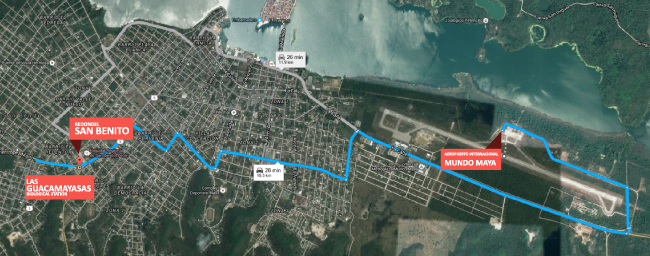
First challenge is to find your way through Santa Elena and San Benito. So focus on finding the main street through San Benito, the city on the mainland which faces the island town of Flores. Santa Elena is the town where the international airport is located. You drive through Santa Elena to reach San Benito (they are simply both suburbs of each other). Both face the Lake Peten Itza and the island of Flores (and the ruins of Tayasal on the other side of the lake).
One way to find your way through any town in Guatemala is to pay a Tuc-tuc driver to lead you to the highway that goes outside that town. Or, ask how to get to a place that is on the road you need to be on. So ask how to get to Hotel Palacio Maya (should be at your left).
A few blocks down the same street is Hotel Oriental #2 at your left with a Gasolinera Puma across the street (keeping in mind that there are Puma gas stations in many other parts of the city).
Then a kilometer or so later you come to a rather larger than normal redondel (or glorieta). It has two fat but not very high ceiba trees at one end. There is a large clearly visible Shell gas station on the far side of the redondel. To the left is a no-brand gas station (which you will not notice since it is far to the left).
Three forks in the road here:
- Far left, goes to La Libertad via San Francisco
- Middle: goes to La Libertad, but not paved
- Right: goes where you want to go
 |
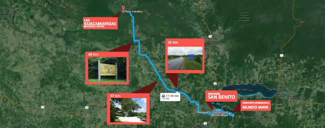 |
Table Parameters
| Landmark | Our Vehicle's odometer | How far from "Flores" |
| San Benito | 601 | 0 Km |
|
Bridge over wide river or narrow lake. You want to take a left immediately after the bridge; to the right goes towards El Mirador (ruins). |
611 | 10 Km from San Benito (suburb of Flores) |
| Long town of Sacpuy | 627, keep straight ahead | 26 Km from San Benito |
| Lots of Palo de Tinto at the left | 631 | 30 Km |
| Caseria Bocadilla | 634 | 33 Km |
| La Union | 635 | 34 Km |
| Another aldea Caseria Atalun San Andres, Caseria La Ceibita | 638, road to the right goes to Juventud, you stay straight | 37 Km |
| Another road to the left; blue church to the right; you stay straight ahead | Km 47 | 46 Km |
| Two Ceiba trees at the right; this is a major turn (to the right) | Km 47 | 46 Km |
| Desvio | Km 50 | 49 Km |
| Paso Caballos, Rio San Pedro Martyr | Km 67 | 66 Km from San Benito |
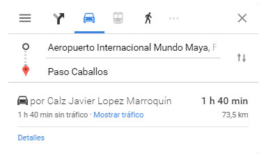
You can also use Google Maps to find your way
 |
Basically, stay on the most traveled road; most turn-offs are not as wide or well traveled as the main road. Most turn-offs to the left go to fincas or haciendas. The only actual intersection where you will actually make a 90-degree turn is at the two Ceiba trees. Here you turn right.There are not really any signs telling you where you are going. Only signs telling you where you are when you notice the school construction signs put up by the government to show that they are spending a least a tad of taxpayer money on something other than corruption. These “Hey, we did spend a few pennies for the public good here in this town school,” give the name of the town, and the name of the municipio (which is San Andres).
Takes between 90 minutes if you drive without stopping to take photos. More likely two hours, depending how fast or how slow you drive. If you stop to take photos, perhaps three hours.
4WD not required but in some months might be very useful. The road is in much better condition now than two years ago. But road condition varies considerably month by month (depending on rainfall and whether anyone in the local government is having the road graded).
One year we had a rented 4WD Volvo SUV. Too low to survive; tore off much of the underside (plus the Volvo was a piece of junk; worst vehicle I have driven, other than a Nissan van which was even more poorly designed than the Volvo).
There is a recently enhanced Catholic church at your left. About 20 or 30 meters turn left and go downhill to the river. It would be not appropriate to take photographs of the village Q’eqchi’ Mayan people bathing in the river.
In Paso Caballos there is a place to leave your car. Just realize that there is not always someone in the house to notify; but simply open the gate and park your car there. Try not to let the turkeys run outside the house yard (but if they do, not fatal). The boat ride to Las Guacamayas varies between 12 and 20 minutes, depending size of the boat’s motor, and whether they or you are in a hurry. If you stop to take a few snapshots, the trip is about half an hour.
There are guides in the village who speak both Q’eqchi’ Mayan and Spanish. I doubt any speak English. Fee is 200 quetzales for a day or half day. Would need to make reservation for the guide through Las Guacamayas, since they know all the local people. For touring within the area of Las Guacamayas, they have their own guides.
In the dry season you can drive all the way to Las Guacamayas and to the ruins of El Peru, but we did not want to risk these seldom traveled trails in the rainy season (which definitely need 4WD). Plus, we stay at Las Guacamayas and not at the ruins.
There is a CONAP stop when you enter the area of the nature reserve. They will ask for your name for their list. This CONAP station is about 4 kilometers from Paso Caballos.
Contact information for Las Guacamayas
administracion@lasGuacamayas.org
You can also read about
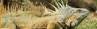
Las Guacamayas Biological Station, Peten, Guatemala
First posted September 2015.
After our fifth visit to Las Guacamayas Biological Station. We appreciate the hospitality of Nini Berger (founder of the current status of this research station) and Jeovany Tut Rodriguez (manager and guide).